New York Tech Media
  • News
  • FinTech
  • AI & Robotics
  • Cybersecurity
  • Startups & Leaders
  • Venture Capital
No Result
View All Result
  • News
  • FinTech
  • AI & Robotics
  • Cybersecurity
  • Startups & Leaders
  • Venture Capital
No Result
View All Result
New York Tech Media
No Result
View All Result
Home AI & Robotics

Projecting Climate Change Into Photos With Generative Adversarial Networks

New York Tech Editorial Team by New York Tech Editorial Team
October 12, 2021
in AI & Robotics
0
Projecting Climate Change Into Photos With Generative Adversarial Networks
Share on FacebookShare on Twitter

A team of researchers from Canada and the US has developed a machine learning method to superimpose the catastrophic effects of climate change into real photos using Generative Adversarial Networks (GANs), with the aim of reducing ‘distancing’ – our inability to relate to hypothetical or abstract scenarios regarding climate change.

ClimateGAN estimates geometry from a calculated depth-map before adding reflectivity in a superimposed water surface. Source: https://arxiv.org/pdf/2110.02871.pdf

ClimateGAN estimates geometry from a calculated depth-map before adding reflectivity in a superimposed water surface. Source: https://arxiv.org/pdf/2110.02871.pdf

The project, titled ClimateGAN, is part of a wider research effort to develop interactive environments where users can explore projected worlds that have been affected by floods, extreme heat, and other serious consequences of climate change.

Discussing the motivation behind the initiative, the researchers state:

‘Climate change is a major threat to humanity, and the actions required to prevent its catastrophic consequences include changes in both policy-making and individual behaviour. However, taking action requires understanding the effects of climate change, even though they may seem abstract and distant.

‘Projecting the potential consequences of extreme climate events such as flooding in familiar places can help make the abstract impacts of climate change more concrete and encourage action.’

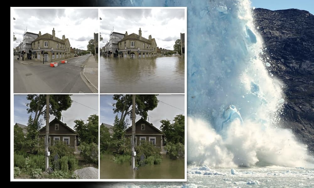
A core aim of the initiative is to enable a system where a user can enter their address (or any address) and see a climate-change affected version of the corresponding image from Google Street View. However, the transformation algorithms behind ClimateGAN require some estimated knowledge of height for items in the photo, which is not included in the metadata Google provides for Street View, and so obtaining such an estimation algorithmically remains an ongoing challenge.

Data and Architecture

ClimateGAN utilizes an unsupervised image-to-image translation pipeline with two phases: a Masker layer, which estimates where a level water surface would theoretically exist in the target image; and a Painter module to realistically render water within the boundaries of the established mask, and takes into account reflectivity of the remaining non-obscured geometry above the waterline.

The architecture for ClimateGAN. Input proceeds through a shared encoder into a three-stage masking process before being passed to the Painter module. The two networks are trained independently, and only operate in tandem during the generation of new images.

The architecture for ClimateGAN. Input proceeds through a shared encoder into a three-stage masking process before being passed to the Painter module. The two networks are trained independently, and only operate in tandem during the generation of new images.

Most of the training data was chosen from the CityScapes and Mapillary datasets. However, since existing data for flood imagery is relatively scarce, the researchers combined existing available datasets with a novel ‘virtual world’ developed with the Unity3D game engine.

Scenes from the Unity3D virtual environment.

Scenes from the Unity3D virtual environment.

The Unity3D world contains around 1.5km of terrain, and includes urban, suburban and rural areas, which the researchers ‘flooded’. This enabled the generation of ‘before’ and ‘after’ images for additional ground truth for the ClimateGAN framework.

The Masker unit adapts the 2018 ADVENT code for training, adding additional data in line with 2019 findings from the French research initiative DADA. The researchers also added a segmentation decoder to feed the Masker unit additional information regarding the semantics of the input image (i.e. labeled information that denotes a domain, such as ‘building’).

The Flood Mask Decoder calculates a feasible waterline, and is powered by NVIDIA’s hugely popular SPADE in-painting framework.

Together with semantic segmentation (third column), depth map information enables delineation of the geometry in a photo, providing a guideline for the margins of the 'flood water'. This can be inferred through machine learning processes, though such information is increasingly being included in consumer-level mobile device sensors. In the lowest row, we see that the ClimateGAN architecture has successfully rendered a 'flooded' version of the original photo even though the intermediate stages have failed to accurately capture the geometry of a complex scene.

Click to enlarge. Together with semantic segmentation (third column), depth map information enables delineation of the geometry in a photo, providing a guideline for the margins of the ‘flood water’. This can be inferred through machine learning processes, though such information is increasingly being included in consumer-level mobile device sensors. In the lowest row, we see that the ClimateGAN architecture has successfully rendered a ‘flooded’ version of the original photo even though the intermediate stages have failed to accurately capture the geometry of a complex scene.

Though the researchers used NVIDIA GauGAN, powered by SPADE, for the Painter module, it was necessary to condition GauGAN on the output of the Masker, and not on a generalized semantic segmentation map, as occurs in normal use, since the images had to be transformed in line with the waterline delineations, rather than being subject to broad, general transformations.

Evaluating Quality

Metrics for evaluating the quality of the resulting images were facilitated by labeling a test set of 180 Google Street View images of varying types, including urban scenes and more rural images from a diversity of geographical locations. The images were manually labeled as cannot-be-flooded, must-be-flooded, and may-be-flooded.

This allowed the formulation of three metrics: error rate (perceived prediction areas by size in the transformed image), F05 Score, and edge coherence. For comparison, the researchers tested the data on prior image-to-image translation (IIT) models, including InstaGAN, CycleGAN, and MUNIT.

In user tests, ClimateGAN was found to achieve a higher degree of realism than five competing IIT architectures. Blue represents the degree to which users preferred ClimateGAN to the studied alternative method.

In user tests, ClimateGAN was found to achieve a higher degree of realism than five competing IIT architectures. Blue represents the degree to which users preferred ClimateGAN to the studied alternative method.

The researchers concede that the lack of height data in source imagery makes it difficult to arbitrarily impose waterline heights in images, if the user would like to dial up the ‘Roland Emmerich factor’ a little. They also concede that the flood effects are overly limited to the flood area, and intend to investigate methods by which multiple levels of flooding (i.e. after recession of an initial deluge) could be added to the methodology.

ClimateGAN’s code has been made available at GitHub, together with additional examples of rendered images.

In another example, from the GitHub presence for the project, smog is added to a city picture in a way that will be familiar to most VFX practitioners – the depth map is used as a kind of receding 'white-out mask', so that the density of smog/fog increases across the distance covered in the photo. Source: https://github.com/cc-ai/climategan

In another example, from the GitHub presence for the project, smog is added to a city picture in a way that will be familiar to most VFX practitioners – the depth map is used as a kind of receding ‘white-out mask’, so that the density of smog/fog increases across the distance covered in the photo. Source: https://github.com/cc-ai/climategan


Credit: Source link

Previous Post

8BitDo’s Xbox media remotes are cute and cheap

Next Post

US PC market declines due to supply issues just as Windows 11 launches

New York Tech Editorial Team

New York Tech Editorial Team

New York Tech Media is a leading news publication that aims to provide the latest tech news, fintech, AI & robotics, cybersecurity, startups & leaders, venture capital, and much more!

Next Post
US PC market declines due to supply issues just as Windows 11 launches

US PC market declines due to supply issues just as Windows 11 launches

  • Trending
  • Comments
  • Latest
Meet the Top 10 K-Pop Artists Taking Over 2024

Meet the Top 10 K-Pop Artists Taking Over 2024

March 17, 2024
Panther for AWS allows security teams to monitor their AWS infrastructure in real-time

Many businesses lack a formal ransomware plan

March 29, 2022
Zach Mulcahey, 25 | Cover Story | Style Weekly

Zach Mulcahey, 25 | Cover Story | Style Weekly

March 29, 2022
How To Pitch The Investor: Ronen Menipaz, Founder of M51

How To Pitch The Investor: Ronen Menipaz, Founder of M51

March 29, 2022
Japanese Space Industry Startup “Synspective” Raises US $100 Million in Funding

Japanese Space Industry Startup “Synspective” Raises US $100 Million in Funding

March 29, 2022
UK VC fund performance up on last year

VC-backed Aerium develops antibody treatment for Covid-19

March 29, 2022
Startups On Demand: renovai is the Netflix of Online Shopping

Startups On Demand: renovai is the Netflix of Online Shopping

2
Robot Company Offers $200K for Right to Use One Applicant’s Face and Voice ‘Forever’

Robot Company Offers $200K for Right to Use One Applicant’s Face and Voice ‘Forever’

1
Menashe Shani Accessibility High Tech on the low

Revolutionizing Accessibility: The Story of Purple Lens

1

Netgear announces a $1,500 Wi-Fi 6E mesh router

0
These apps let you customize Windows 11 to bring the taskbar back to life

These apps let you customize Windows 11 to bring the taskbar back to life

0
This bipedal robot uses propeller arms to slackline and skateboard

This bipedal robot uses propeller arms to slackline and skateboard

0
Coffee Nova’s $COFFEE Token

Coffee Nova’s $COFFEE Token

May 29, 2025
Money TLV website

BridgerPay to Spotlight Cross-Border Payments Innovation at Money TLV 2025

May 27, 2025
The Future of Software Development: Why Low-Code Is Here to Stay

Building Brand Loyalty Starts With Your Team

May 23, 2025
Tork Media Expands Digital Reach with Acquisition of NewsBlaze and Buzzworthy

Creative Swag Ideas for Hackathons & Launch Parties

May 23, 2025
Tork Media Expands Digital Reach with Acquisition of NewsBlaze and Buzzworthy

Strengthening Cloud Security With Automation

May 22, 2025
How Local IT Services in Anderson Can Boost Your Business Efficiency

Why VPNs Are a Must for Entrepreneurs in Asia

May 22, 2025

Recommended

Coffee Nova’s $COFFEE Token

Coffee Nova’s $COFFEE Token

May 29, 2025
Money TLV website

BridgerPay to Spotlight Cross-Border Payments Innovation at Money TLV 2025

May 27, 2025
The Future of Software Development: Why Low-Code Is Here to Stay

Building Brand Loyalty Starts With Your Team

May 23, 2025
Tork Media Expands Digital Reach with Acquisition of NewsBlaze and Buzzworthy

Creative Swag Ideas for Hackathons & Launch Parties

May 23, 2025

Categories

  • AI & Robotics
  • Benzinga
  • Cybersecurity
  • FinTech
  • New York Tech
  • News
  • Startups & Leaders
  • Venture Capital

Tags

3D bio-printing acoustic AI Allseated B2B marketing Business carbon footprint climate change coding Collaborations Companies To Watch consumer tech crypto cryptocurrency deforestation drones earphones Entrepreneur Fetcherr Finance Fintech food security Investing Investors investorsummit israelitech Leaders LinkedIn Leaders Metaverse news OurCrowd PR Real Estate reforestation software start- up Startups Startups On Demand startuptech Tech Tech leaders technology UAVs Unlimited Robotics VC
  • Contact Us
  • Privacy Policy
  • Terms and conditions

© 2024 All Rights Reserved - New York Tech Media

No Result
View All Result
  • News
  • FinTech
  • AI & Robotics
  • Cybersecurity
  • Startups & Leaders
  • Venture Capital

© 2024 All Rights Reserved - New York Tech Media