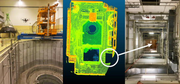
During the EnRicH 2021 European Robotics Hackathon, Southwest Research Institute’s unmanned aircraft system (UAS) explored and mapped the interior of a nuclear power plant, detecting radiation sources, autonomously without the aid of a human pilot.
SwRI’s UAS, or drone, technology can potentially assist in life-saving search-and-rescue missions and hazardous inspections at industrial facilities and infrastructure following natural disasters and other incidents.
The hackathon took place Oct. 4-8 in Austria’s Zwentendorf Nuclear Power Plant, the only nuclear facility that has been completely built but never activated. The inoperable boiling water reactor plant serves as a training ground to prepare for radiological and nuclear incidents and disaster scenarios.
From left, the SwRI drone hovers next to an orange crane used to lower fuel rods into a containment vessel. Middle, a LIDAR image shows the drone’s point of view as it hovers above the containment vessel entrance (blue/green circle) and crane (orange rectangle). The dark rectangle at bottom right is a ventilation shaft. Right, the drone flew in the ventilation shaft, traveling 40 meters vertically to the area housing the crane. A radiation detector aboard the drone identified Cobalt-60, a radioisotope, in a red pipe located in the shaft.
Today’s drones and ground robots typically require a lot from a human operator. The autonomy we’ve demonstrated has the potential to significantly reduce the burden on human operators, allowing robotic systems to act independently and operate themselves.
—Eric Thorn, manager of SwRI’s UAS research team
Developed and tested through internally funded research, SwRI’s technology combines new algorithms with computer vision sensors to allow drones to explore and map previously unknown environments autonomously.
We’ve developed a full autonomy stack that can be paired with a variety of sensors and UAS platforms to perform critical missions.
—Eric Thorn
SwRI’s EnRicH entry featured a four-axis drone equipped with several sensors—light detection and ranging (LIDAR), a time-of-flight camera and radiation detectors. The team utilized both on-drone processors and ground-based processing to perform simultaneous localization and mapping (SLAM), exploration, decision-making, autopilot, computer vision analysis, sensing and other tasks.
Using algorithms and modeling tools, the technology maps the spatial topography of internal structures and open spaces in real-time. Fusing data from computer vision sensors, the technology maps routes as it explores new locations. Perception techniques to detect people, vehicles and other objects are also available based on convolutional neural networks (CNNs).
During the EnRicH hackathon, the drone autonomously detected two sources of cobalt-60, a radioisotope, hidden in separate locations as part of a pre-planned challenge. Participants had no prior information about the facility, or the exploration challenges created by a panel of judges.
SwRI’s autonomy stack has been used in everything from commercial and military connected and autonomous ground vehicles to automated drones and intelligent agricultural equipment. It leverages open-source tools such as the robot operating system (ROS) and proprietary machine learning algorithms and artificial intelligence.
Credit: Source link


